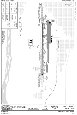


UTDD - Dushanbe
Located in Dushanbe, Tajikistan
ICAO - UTDD, IATA - DYU
Data provided by AirmateGeneral information
Coordinates: N38°32'37" E68°49'29"
Elevation is 2568 feet MSL.
View others Airports in Region of Republican Subordination
Operational data
Special qualification required
Current time UTC:
Current local time:
Weather
METAR: UTDD 270930Z VRB02MPS 9999 -SHRA SCT041CB SCT041 13/10 Q1017 R09/29//50 NOSIG RMK QFE694/0926
TAF: TAF UTDD 270500Z 2706/2806 VRB02MPS 6000 -SHRA SCT030CB BKN060 PROB40 TEMPO 2706/2718 -TSRA
Communications frequencies: [VIEW]
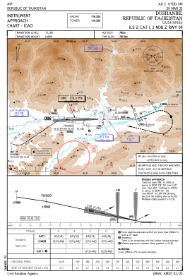
Runways:
| RWY identifier | QFU | Length (ft) | Width (ft) | Surface | LDA (ft) |
| 09 | 90° | 10210 | 148 | ASP | |
| 27 | 270° | 10210 | 148 | ASP |
Airport contact information
Address: Dushanbe Tajikistan