


UGSA - Natakhtari
Located in Mtskheta, Georgia
ICAO - , IATA -
Data provided by AirmateGeneral information
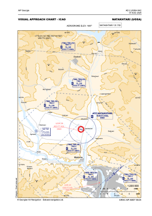
Coordinates: N41°55'14" E44°43'10"
Elevation is 1687 feet MSL.
Magnetic variation is 7° East View others Airports in Mtskheta-Mtianeti
Operational data
Special qualification required
Current time UTC:
Current local time:
Weather at : UGTB - Tbilisi/Tbilisi ( 34 km )
METAR: UGTB 280830Z 16006KT 100V230 CAVOK 25/11 Q1022 NOSIG
TAF: TAF UGTB 280500Z 2806/2906 16010KT CAVOK TX28/2812Z TN13/2902Z BECMG 2816/2818 04006KT TEMPO 2821/2903 SCT050CB
Communications frequencies: [VIEW]
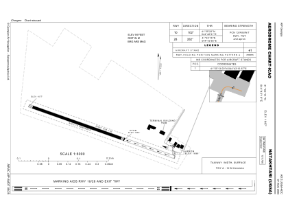
Runways:
| RWY identifier | QFU | Length (ft) | Width (ft) | Surface | LDA (ft) |
| 10 | 109° | 3110 | 59 | CONC | 3110 |
| 28 | 289° | 3110 | 59 | CONC | 2034 |
Airport contact information
Address: Mtskheta Georgia