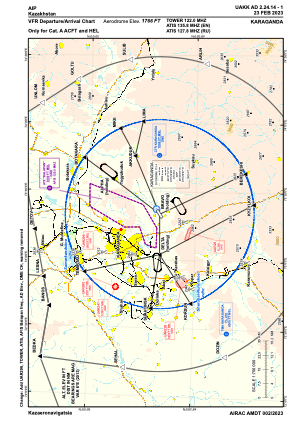
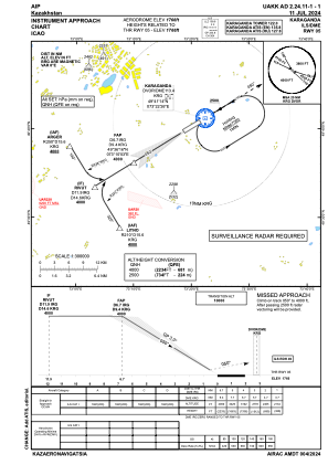
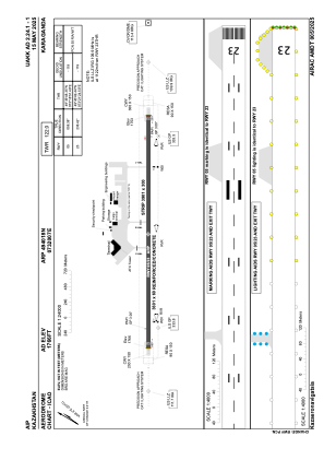


UAKK - Karaganda
Located in Karaganda, Kazakhstan
ICAO - UAKK, IATA - KGF
Data provided by AirmateGeneral information
Coordinates: N49°40'18" E73°20'7"
Elevation is 1766 feet MSL.
Magnetic variation is 8° East View others Airports in Karagandy
Operational data
Special qualification required
Current time UTC:
Current local time:
Weather
METAR: UAKK 022300Z 25003MPS CAVOK 03/02 Q1005 NOSIG RMK QFE708/0944
TAF: TAF UAKK 021702Z 0218/0318 25006MPS 9999 SCT030 BKN100 TX17/0309Z TN03/0223Z TEMPO 0218/0303 VRB02MPS 2000 -RA BR BKN006 BKN040 BECMG 0303/0305 27006MPS TEMPO 0303/0314 28011MPS 5000 -SHRA SCT011 BKN020CB BECMG 0314/0316 12005MPS
Communications frequencies: [VIEW]
Runways:
| RWY identifier | QFU | Length (ft) | Width (ft) | Surface | LDA (ft) |
| 05 | 58° | 11814 | 197 | CONC | 11814 |
| 23 | 238° | 11814 | 197 | CONC | 11814 |
Airport contact information
Address: Karaganda Kazakhstan