


TIST - Cyril E King
Located in Charlotte Amalie, U.S. Virgin Islands
ICAO - STT, IATA - STT
Data provided by AirmateGeneral information
Coordinates: N18°20'14" W64°58'24"
Elevation is 24 feet MSL.
Magnetic variation is -13° East View others Airports in (unassigned)
Operational data
Special qualification required
Current time UTC:
Current local time:
Weather
METAR: TIST 040253Z 11012KT 10SM -RA BKN030 27/26 A2992 RMK AO2 SLP131 6//// T02720256 53015 PNO
TAF: TIST 032340Z 0400/0424 10008KT P6SM -RA BKN025 BKN050 TEMPO 0400/0402 1SM TSRA BKN015CB FM041400 13008KT P6SM -RA SCT030 BKN060 FM042300 VRB06KT P6SM -RA FEW025 SCT050
Communications frequencies: [VIEW]
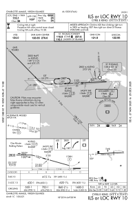
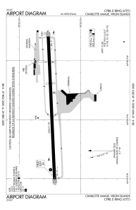
Runways:
| RWY identifier | QFU | Length (ft) | Width (ft) | Surface | LDA (ft) |
| 10 | 87° | 7000 | 150 | ASPH | 6892 |
| 28 | 267° | 7000 | 150 | ASPH | 3870 |
Airport contact information
Address: Charlotte Amalie U.S. Virgin Islands
