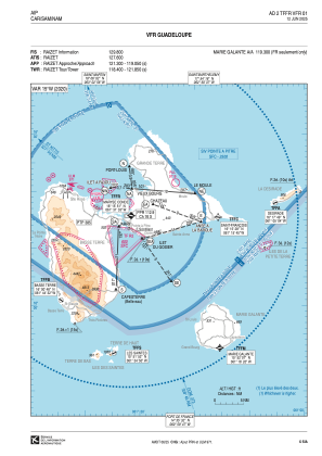
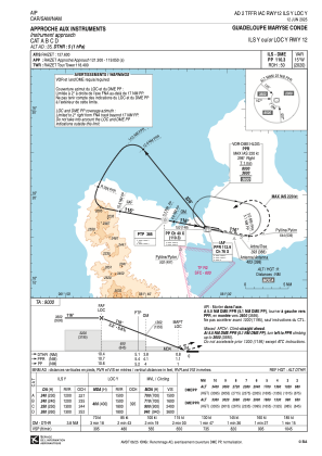
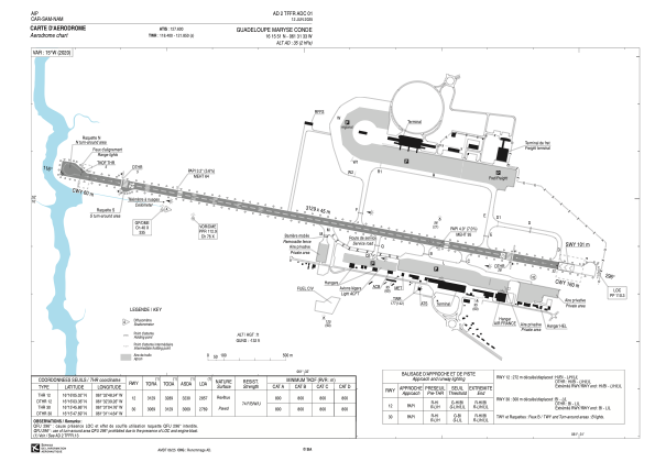


TFFR - Pointe A Pitre Le Raizet
Located in Pointe A Pitre (Guadeloupe), Guadeloupe
ICAO - TFFR, IATA - PRP
Data provided by AirmateGeneral information
Coordinates: N16°15'51" W61°31'33"
Elevation is 35 feet MSL.
Magnetic variation is -14.92° East View others Airports in (unassigned)
Operational data
Special qualification required
Current time UTC:
Current local time:
Weather
METAR: TFFR 290730Z AUTO VRB02KT 9999 ///TCU 24/22 Q1012 BECMG SCT030 BKN070
TAF: TAF TFFR 290500Z 2906/3006 VRB02KT 9999 SCT030 BKN070 BECMG 2911/2913 11010KT TEMPO 2913/2924 4000 SHRA BKN015TCU SCT030 BKN070 PROB30 TEMPO 2915/2920 2500 TSRA SCT012CB BKN015TCU SCT030 BKN070 BECMG 2921/2923 VRB02KT
Communications frequencies: [VIEW]
Runways:
| RWY identifier | QFU | Length (ft) | Width (ft) | Surface | LDA (ft) |
| 12 | 101° | 10266 | 148 | ASPH | 9373 |
| 30 | 281° | 10266 | 148 | ASPH | 9085 |
Airport contact information
Address: Pointe A Pitre (Guadeloupe) Guadeloupe
Other aviation service providers
Aviation club (not for profit)

Aéroclub de l'Aviation Civile et de Guadeloupe
Aéroclub de l'Aviation Civile et de Guadeloupe
bureau_acacg@yahoo.fr+330590482146