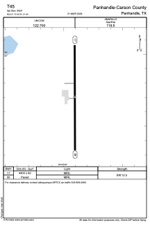


T45 - Panhandle-Carson County
Located in Panhandle, United States
ICAO - T45, IATA -
Data provided by AirmateGeneral information
Coordinates: N35°21'42" W101°21'54"
Elevation is 3454 feet MSL.
Magnetic variation is 08° East View others Airports in Texas
Operational data
Special qualification required
Current time UTC:
Current local time:
Weather at : KAMA - Rick Husband Amarillo Intl ( 35 km )
METAR: KAMA 011453Z 23010KT 10SM CLR 20/12 A2983 RMK AO2 SLP056 T02000122 51005
TAF: KAMA 011141Z 0112/0212 21011KT P6SM SKC FM011430 21016G25KT 5SM BR BKN030 FM011700 20017G27KT P6SM SKC FM020200 16019G29KT P6SM SCT220 FM021000 20014KT P6SM FEW210 FM021100 23014KT P6SM SCT190
Communications frequencies: [VIEW]
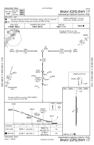
Runways:
| RWY identifier | QFU | Length (ft) | Width (ft) | Surface | LDA (ft) |
| 17 | 180° | 4404 | 60 | ASPH | |
| 35 | 360° | 4404 | 60 | ASPH |
Airport contact information
Address: Panhandle United States