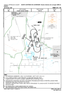


SWLV - Santo Antonio De Leverger
Located in Santo Antonio Do Leverger, Brazil
ICAO - SWLV, IATA -
Data provided by AirmateGeneral information
Coordinates: S15°51'4" W56°5'16"
Elevation is 557 feet MSL.
Magnetic variation is -18.056494083° East View others Airports in Mato Grosso
Operational data
Special qualification required
Current time UTC:
Current local time:
Weather at : SBCY - Marechal Rondon ( 23 km )
METAR: SBCY 041100Z 31004KT CAVOK 24/22 Q1012
TAF: TAF SBCY 040921Z 0412/0512 26005KT 9999 FEW025 TX36/0418Z TN23/0509Z BECMG 0412/0413 30007KT BECMG 0418/0420 34005KT BECMG 0500/0503 25005KT CAVOK RMK PGA
Communications frequencies: [VIEW]
Runways:
| RWY identifier | QFU | Length (ft) | Width (ft) | Surface | LDA (ft) |
| 01 | 0° | 5577 | 75 | ASPH | |
| 19 | 0° | 5577 | 75 | ASPH |
Airport contact information
Address: Santo Antonio Do Leverger Brazil