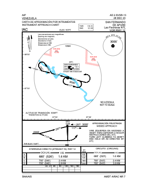
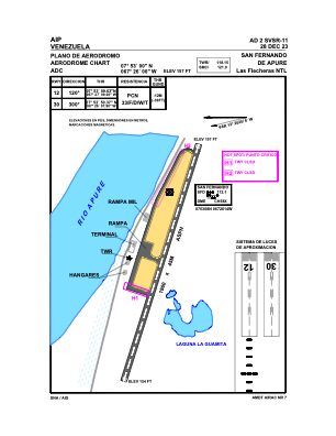


SVSR - San Fernando De Apure / Las Flecheras Ntl
Located in San Fernando De Apure, Venezuela
ICAO - SVSR, IATA - SFD
Data provided by AirmateGeneral information
Coordinates: N7°52'59" W67°26'37"
Elevation is 157 feet MSL.
Magnetic variation is -12° East View others Airports in Apure
Operational data
Special qualification required
Current time UTC:
Current local time:
Weather at : - ( 0 km )
METAR: ZMCK 280830Z 32005MPS 9999 SCT033 06/M11 Q1020 NOSIG RMK QFE649.0 28 MOP
Communications frequencies: [VIEW]
Runways:
| RWY identifier | QFU | Length (ft) | Width (ft) | Surface | LDA (ft) |
| 12 | 108° | 6378 | 150 | ASPH | 6430 |
| 30 | 288° | 6378 | 150 | ASPH | 6430 |
Airport contact information
Address: San Fernando De Apure Venezuela