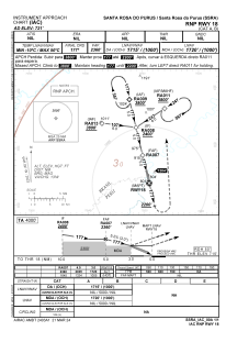


SSRA - Santa Rosa Do Purus
Located in Santa Rosa Do Purus, Brazil
ICAO - SSRA, IATA -
Data provided by AirmateGeneral information
Coordinates: S9°26'47" W70°28'58"
Elevation is 720 feet MSL.
Magnetic variation is -8° East View others Airports in Acre
Operational data
Special qualification required
Current time UTC:
Current local time:
Weather at : - ( 0 km )
METAR: KUNV 271853Z 20006KT 10SM OVC016 09/08 A3034
Communications frequencies: [VIEW]
Runways:
| RWY identifier | QFU | Length (ft) | Width (ft) | Surface | LDA (ft) |
| 18 | 0° | 3609 | 75 | GRASS | |
| 36 | 0° | 3609 | 75 | GRASS |
Airport contact information
Address: Santa Rosa Do Purus Brazil