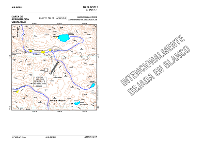
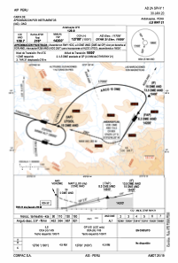


SPHY - Andahuaylas
Located in Andahuaylas, Peru
ICAO - SPHY, IATA - ANS
Data provided by AirmateGeneral information
Coordinates: S13°42'32" W73°21'6"
Elevation is 11706 feet MSL.
View others Airports in Apurímac Region
Operational data
Special qualification required
Current time UTC:
Current local time:
Weather
METAR: SPHY 031600Z 01004KT 9999 SCT012 BKN060 13/09 Q1034 RMK BIRD HAZARD RWY03/21 PP000
TAF: TAF SPHY 031100Z 0312/0412 17003KT 9999 SCT012 BKN060 TX19/0319Z TN02/0411Z TEMPO 0318/0322 05010KT
Communications frequencies: [VIEW]
Runways:
| RWY identifier | QFU | Length (ft) | Width (ft) | Surface | LDA (ft) |
| 03 | 32° | 8202 | 148 | ASP | |
| 21 | 212° | 8202 | 148 | ASP |
Airport contact information
Address: Andahuaylas Peru