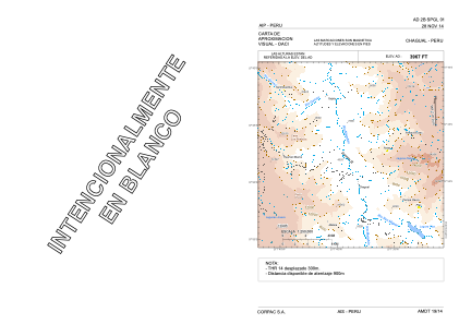


SPGL - Chagual
Located in , Peru
ICAO - SPGL, IATA -
Data provided by AirmateGeneral information
Coordinates: S7°47'51" W77°39'5"
Elevation is 3967 feet MSL.
View others Airports in La Libertad Region
Operational data
Special qualification required
Current time UTC:
Current local time:
Weather at : - ( 0 km )
METAR: YCFS 060841Z AUTO 16015KT 9999 -SHRA SCT031 SCT056 BKN067 20/17 Q1023 RESHRA
Communications frequencies: [VIEW]
Runways:
| RWY identifier | QFU | Length (ft) | Width (ft) | Surface | LDA (ft) |
| 14 | 135° | 3937 | 59 | UNK | |
| 32 | 315° | 3937 | 59 | UNK |
Airport contact information
Address: Peru