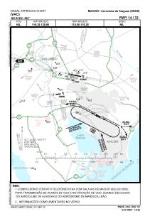


SNGS - Aeroclube De Alagoas
Located in Maceio, Brazil
ICAO - SNGS, IATA -
Data provided by AirmateGeneral information
Coordinates: S9°35'15" W35°45'28"
Elevation is 295 feet MSL.
Magnetic variation is -22.221165957° East View others Airports in Alagoas
Operational data
Special qualification required
Current time UTC:
Current local time:
Weather at : SBMO - Zumbi Dos Palmares ( 9 km )
METAR: SBMO 030900Z 31003KT 9999 FEW023 24/23 Q1011
TAF: TAF SBMO 030900Z 0312/0412 11010KT 9999 SCT025 TX30/0316Z TN25/0407Z BECMG 0321/0323 07005KT FEW020 BECMG 0402/0404 29005KT SCT015 BECMG 0410/0412 10005KT SCT015 RMK PHD
Communications frequencies: [VIEW]
Runways:
| RWY identifier | QFU | Length (ft) | Width (ft) | Surface | LDA (ft) |
| 14 | 0° | 2625 | 69 | ASPH | |
| 32 | 0° | 2625 | 69 | ASPH |
Airport contact information
Address: Maceio Brazil