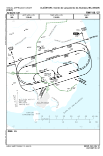
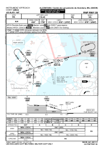


SNCW - Centro De Lançamento De Alcântara
Located in Alcântara, Brazil
ICAO - SNCW, IATA -
Data provided by AirmateGeneral information
Coordinates: S2°22'18" W44°23'27"
Elevation is 148 feet MSL.
View others Airports in Maranhão
Operational data
Special qualification required
Current time UTC:
Current local time:
Weather at : SBSL - Marechal Cunha Machado ( 29 km )
METAR: SBSL 290000Z 06003KT CAVOK 26/25 Q1011
TAF: TAF SBSL 282002Z 2900/2924 26006KT 9999 SCT020 TN24/2909Z TX29/2916Z BECMG 2915/2917 02008KT SCT020 FEW030TCU PROB40 TEMPO 2920/2922 TS SCT020 FEW030CB RMK PGX
Communications frequencies: [VIEW]
Runways:
| RWY identifier | QFU | Length (ft) | Width (ft) | Surface | LDA (ft) |
| 27 | 0° | 8530 | 148 | ASPH | |
| 09 | 0° | 8530 | 148 | ASPH |
Airport contact information
Address: Alcântara Brazil