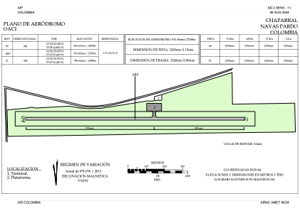


SKHA - Chaparral Navas Pardo
Located in Chaparral, Colombia
ICAO - SKHA, IATA - CPL
Data provided by AirmateGeneral information
Coordinates: N3°43'26" W75°27'55"
Elevation is 2730 feet MSL.
Magnetic variation is -7° East View others Airports in Tolima
Operational data
Special qualification required
Current time UTC:
Current local time:
Weather at : - ( 0 km )
METAR: K3U3 280745Z AUTO 00000KT 10SM 04/03 A2995
Communications frequencies: [VIEW]
Runways:
| RWY identifier | QFU | Length (ft) | Width (ft) | Surface | LDA (ft) |
| 09 | 84° | 3934 | 49 | GRAV | 3937 |
| 27 | 264° | 3934 | 49 | GRAV | 3937 |
Airport contact information
Address: Chaparral Colombia