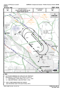
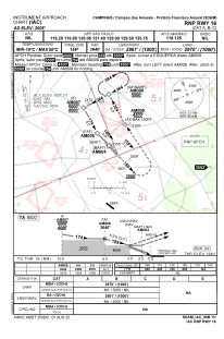


SDAM - Estadual De Campos Dos Amarais - Prefeito Francisco Amaral
Located in Campinas, Brazil
ICAO - SDAM, IATA - CPQ
Data provided by AirmateGeneral information
Coordinates: S22°51'33" W47°6'29"
Elevation is 2008 feet MSL.
Magnetic variation is -21.716666667° East View others Airports in São Paulo
Operational data
Special qualification required
Current time UTC:
Current local time:
Weather at : SBKP - Viracopos ( 17 km )
METAR: SBKP 300600Z 11006KT CAVOK 21/17 Q1016
TAF: TAF SBKP 300430Z 3006/0106 11007KT CAVOK TN20/3009Z TX32/3017Z PROB30 3009/3012 5000 BR BECMG 3013/3015 33010KT FEW045 BECMG 3021/3023 10005KT CAVOK RMK PGL
Communications frequencies: [VIEW]
Runways:
| RWY identifier | QFU | Length (ft) | Width (ft) | Surface | LDA (ft) |
| 16 | 0° | 5807 | 262 | ASPH | |
| 34 | 0° | 5807 | 262 | ASPH |
Airport contact information
Address: Campinas Brazil
