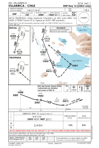


SCVI - Villarrica
Located in Villarrica, Chile
ICAO - SCVI, IATA -
Data provided by AirmateGeneral information
Coordinates: S39°19'2" W72°13'42"
Elevation is 967 feet MSL.
Magnetic variation is 6° East View others Airports in Araucanía
Operational data
Special qualification required
Current time UTC:
Current local time:
Weather at : SCQP - La Araucania ( 57 km )
METAR: SCQP 282000Z 02011KT 9999 -SHRA SCT025 OVC030 12/10 Q1010
TAF: TAF SCQP 281626Z 2818/2918 36010KT 9999 BKN030 BKN045 TX14/2818Z TN09/2910Z BECMG 2906/2908 7000 RA BKN030 BKN060 TEMPO 2907/2913 01025G35KT 5000 RA OVC020 BECMG 2915/2917 30016KT 6000 SHRA BKN020 BKN070
Communications frequencies: [VIEW]
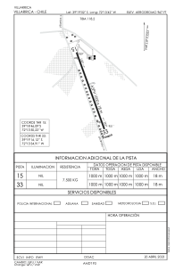
Runways:
| RWY identifier | QFU | Length (ft) | Width (ft) | Surface | LDA (ft) |
| 15 | 158° | 3270 | 43 | ASPH | |
| 33 | 338° | 3270 | 43 | ASPH |
Airport contact information
Address: Villarrica Chile
