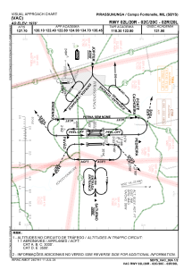
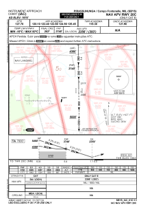
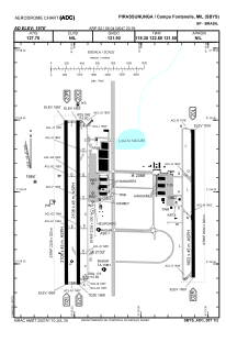


SBYS - Campo Fontenelle
Located in Pirassununga, Brazil
ICAO - SBYS, IATA - QPS
Data provided by AirmateGeneral information
Coordinates: S21°59'4" W47°20'39"
Elevation is 1976 feet MSL.
Magnetic variation is -21.75° East View others Airports in São Paulo
Operational data
Special qualification required
Current time UTC:
Current local time:
Weather
TAF: TAF SBYS 292100Z 3000/3012 09006KT CAVOK TN17/3008Z TX25/3012Z PROB30 3008/3011 2000 BR SCT002 RMK PDJ
Communications frequencies: [VIEW]
Runways:
| RWY identifier | QFU | Length (ft) | Width (ft) | Surface | LDA (ft) |
| 02C | 0° | 6923 | 148 | ASPH | |
| 20C | 0° | 6923 | 148 | ASPH | |
| 02R | 0° | 6240 | 148 | ASPH | |
| 20L | 0° | 6240 | 148 | ASPH | |
| 02L | 0° | 6916 | 148 | ASPH | |
| 20R | 0° | 6916 | 148 | ASPH |
Airport contact information
Address: Pirassununga Brazil