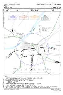
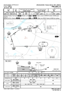
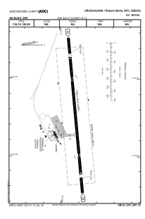


SBUG - Rubem Berta
Located in Uruguaiana, Brazil
ICAO - SBUG, IATA - URG
Data provided by AirmateGeneral information
Coordinates: S29°46'60" W57°2'13"
Elevation is 255 feet MSL.
Magnetic variation is -13.36333009° East View others Airports in Rio Grande do Sul
Operational data
Special qualification required
Current time UTC:
Current local time:
Weather
TAF: TAF SBUG 051500Z 0518/0606 09007KT 9999 BKN026 TX25/0518Z TN22/0606Z PROB30 0603/0606 4000 BR BKN008 RMK PEC
Communications frequencies: [VIEW]
Runways:
| RWY identifier | QFU | Length (ft) | Width (ft) | Surface | LDA (ft) |
| 09 | 85° | 5315 | 492 | ASPH | |
| 27 | 265° | 5315 | 492 | ASPH |
Airport contact information
Address: Uruguaiana Brazil