


SBSM - Santa Maria
Located in Santa Maria, Brazil
ICAO - SBSM, IATA - RIA
Data provided by AirmateGeneral information
Coordinates: S29°42'39" W53°41'32"
Elevation is 288 feet MSL.
Magnetic variation is -15.85° East View others Airports in Rio Grande do Sul
Operational data
Special qualification required
Current time UTC:
Current local time:
Weather
TAF: TAF SBSM 052100Z 0600/0612 05005KT 9999 SCT035 TN23/0607Z TX25/0611Z TEMPO 0603/0609 3500 BR BKN005 RMK PEC
Communications frequencies: [VIEW]
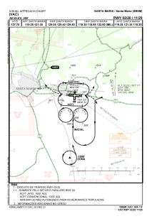
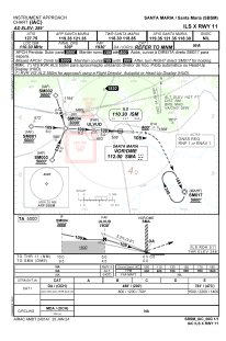
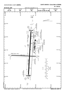
Runways:
| RWY identifier | QFU | Length (ft) | Width (ft) | Surface | LDA (ft) |
| 20 | 0° | 5331 | 492 | ASPH | |
| 11 | 0° | 9626 | 984 | CONC | |
| 29 | 0° | 9626 | 984 | CONC | |
| 02 | 0° | 5331 | 492 | ASPH |
Airport contact information
Address: Santa Maria Brazil