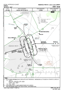
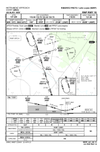
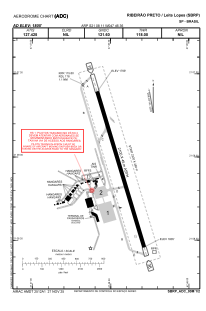


SBRP - Leite Lopes
Located in Ribeirão Preto, Brazil
ICAO - SBRP, IATA - RAO
Data provided by AirmateGeneral information
Coordinates: S21°8'11" W47°46'36"
Elevation is 1804 feet MSL.
Magnetic variation is -21.683333333° East View others Airports in São Paulo
Operational data
Special qualification required
Current time UTC:
Current local time:
Communications frequencies: [VIEW]
Runways:
| RWY identifier | QFU | Length (ft) | Width (ft) | Surface | LDA (ft) |
| 18 | 163° | 7283 | 919 | ASPH | |
| 36 | 343° | 7283 | 919 | ASPH |
Airport contact information
Address: Ribeirão Preto Brazil
Other aviation service providers
Aviation club (not for profit)

Sou Piloto Escola de Aviação Civil
Sou Piloto Escola de Aviação Civil
contato@soupiloto.com.br+5516981535333