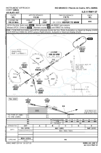
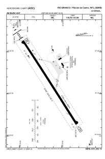


SBRB - Rio Branco / Plácido De Castro
Located in Rio Branco / Plácido De Castro, Brazil
ICAO - SBRB, IATA - RBR
Data provided by AirmateGeneral information
Coordinates: S9°52'6" W67°53'53"
Elevation is 633 feet MSL.
Magnetic variation is -10.0° East View others Airports in Acre
Operational data
Special qualification required
Current time UTC:
Current local time:
Weather
METAR: SBRB 281200Z 29001KT 9999 FEW004 SCT100 26/25 Q1012
TAF: TAF SBRB 280300Z 2806/2818 34005KT 9999 FEW025 TN23/2806Z TX32/2818Z BECMG 2811/2813 29005KT SCT025 BECMG 2815/2817 35005KT BKN030 RMK PHD
Communications frequencies: [VIEW]
Runways:
| RWY identifier | QFU | Length (ft) | Width (ft) | Surface | LDA (ft) |
| 06 | 58° | 2278 | 280 | ASPH | |
| 24 | 238° | 2278 | 280 | ASPH |
Airport contact information
Address: Rio Branco / Plácido De Castro Brazil