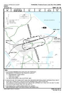
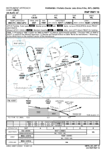
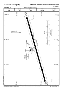


SBPB - Prefeito Doutor João Silva Filho
Located in Parnaíba, Brazil
ICAO - SBPB, IATA - PHB
Data provided by AirmateGeneral information
Coordinates: S2°53'36" W41°43'49"
Elevation is 22 feet MSL.
Magnetic variation is -20.766666667° East View others Airports in Piauí
Operational data
Special qualification required
Current time UTC:
Current local time:
Weather
METAR: SBPB 291500Z 02007KT 9999 SCT020 31/25 Q1010
TAF: TAF SBPB 291500Z 2918/3006 02010KT 9999 SCT020 TX32/2918Z TN28/3006Z TEMPO 2918/2924 33005KT TS BKN015 FEW025CB RMK PGY
Communications frequencies: [VIEW]
Runways:
| RWY identifier | QFU | Length (ft) | Width (ft) | Surface | LDA (ft) |
| 10 | 0° | 8596 | 492 | ASPH | |
| 28 | 0° | 8596 | 492 | ASPH |
Airport contact information
Address: Parnaíba Brazil