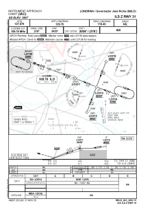
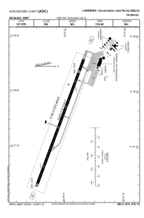


SBLO - Governador José Richa
Located in Londrina, Brazil
ICAO - SBLO, IATA - LDB
Data provided by AirmateGeneral information
Coordinates: S23°19'49" W51°8'12"
Elevation is 1867 feet MSL.
Magnetic variation is -19.75° East View others Airports in Paraná
Operational data
Special qualification required
Current time UTC:
Current local time:
Weather
METAR: SBLO 010100Z 04004KT CAVOK 28/22 Q1015
TAF: TAF SBLO 302200Z 0100/0112 19002KT CAVOK TX27/0100Z TN21/0110Z RMK PGE
Communications frequencies: [VIEW]
Runways:
| RWY identifier | QFU | Length (ft) | Width (ft) | Surface | LDA (ft) |
| 13 | 0° | 7283 | 919 | ASPH | |
| 31 | 0° | 7283 | 919 | ASPH |
Airport contact information
Address: Londrina Brazil
