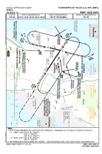
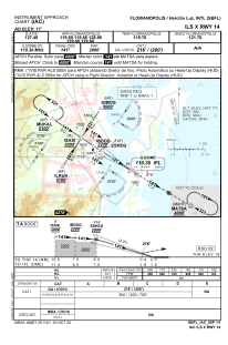
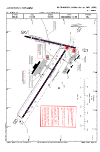


SBFL - Hercílio Luz
Located in Florianopolis, Brazil
ICAO - SBFL, IATA - FLN
Data provided by AirmateGeneral information
Coordinates: S27°40'13" W48°33'9"
Elevation is 16 feet MSL.
Magnetic variation is -19.983333333° East View others Airports in Santa Catarina
Operational data
Special qualification required
Current time UTC:
Current local time:
Weather
METAR: SBFL 011600Z 10007KT CAVOK 27/22 Q1010
TAF: TAF SBFL 011500Z 0118/0218 34009KT CAVOK TX27/0118Z TN22/0205Z BECMG 0120/0122 9999 SCT030 PROB30 0202/0206 4000 BR SCT008 BECMG 0210/0212 CAVOK BECMG 0216/0218 36012KT 9999 SCT025 FEW040TCU RMK PFP
Communications frequencies: [VIEW]
Runways:
| RWY identifier | QFU | Length (ft) | Width (ft) | Surface | LDA (ft) |
| 03 | 12° | 4724 | 262 | CONC | |
| 21 | 192° | 4724 | 262 | CONC | |
| 14 | 121° | 8661 | 919 | ASPH | |
| 32 | 301° | 8661 | 919 | ASPH |
Airport contact information
Address: Florianopolis Brazil