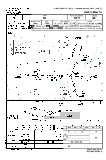
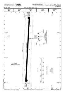


SBCZ - Cruzeiro Do Sul / Cruzeiro Do Sul
Located in Cruzeiro Do Sul / Cruzeiro Do Sul, Brazil
ICAO - SBCZ, IATA - CZS
Data provided by AirmateGeneral information
Coordinates: S7°35'58" W72°46'10"
Elevation is 636 feet MSL.
Magnetic variation is -7.0° East View others Airports in Acre
Operational data
Special qualification required
Current time UTC:
Current local time:
Weather
METAR: SBCZ 271400Z 04004KT 9999 BKN015 BKN100 27/25 Q1013
TAF: TAF SBCZ 270810Z 2712/2812 32006KT 8000 SCT025 FEW035TCU TX32/2721Z TN24/2809Z TEMPO 2718/2723 6000 TS BKN025 FEW035CB BECMG 2801/2803 BKN025 RMK PGX
Communications frequencies: [VIEW]
Runways:
| RWY identifier | QFU | Length (ft) | Width (ft) | Surface | LDA (ft) |
| 10 | 93° | 2520 | 300 | ASPH | |
| 28 | 273° | 2520 | 300 | ASPH |
Airport contact information
Address: Cruzeiro Do Sul / Cruzeiro Do Sul Brazil