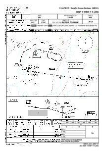
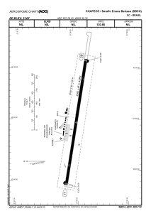


SBCH - Serafin Enoss Bertaso
Located in Chapecó, Brazil
ICAO - SBCH, IATA - XAP
Data provided by AirmateGeneral information
Coordinates: S27°8'2" W52°39'32"
Elevation is 2154 feet MSL.
Magnetic variation is -17.733333333° East View others Airports in Santa Catarina
Operational data
Special qualification required
Current time UTC:
Current local time:
Weather
METAR: SBCH 011700Z 34015KT 9999 SHRA SCT025 FEW040TCU BKN070 29/25 Q1011
Communications frequencies: [VIEW]
Runways:
| RWY identifier | QFU | Length (ft) | Width (ft) | Surface | LDA (ft) |
| 11 | 0° | 7152 | 919 | ASPH | |
| 29 | 0° | 7152 | 919 | ASPH |
Airport contact information
Address: Chapecó Brazil
