


SBBV - Boa Vista / Atlas Brasil Cantanhede
Located in Boa Vista, Brazil
ICAO - SBBV, IATA - BVB
Data provided by AirmateGeneral information
Coordinates: N2°50'29" W60°41'32"
Elevation is 275 feet MSL.
Magnetic variation is -16.0° East View others Airports in Roraima
Operational data
Special qualification required
Current time UTC:
Current local time:
Weather
METAR: SBBV 281900Z 12011G22KT 9999 VCSH BKN040 FEW045TCU 33/22 Q1007
TAF: TAF SBBV 281642Z 2818/2918 10007KT 9999 SCT030 FEW035TCU TX34/2819Z TN25/2909Z BECMG 2823/2901 FEW030 BECMG 2914/2916 7000 RA BKN020 FEW025TCU RMK PFV
Communications frequencies: [VIEW]
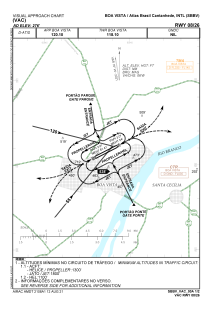
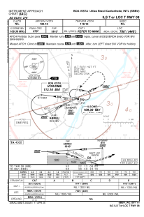
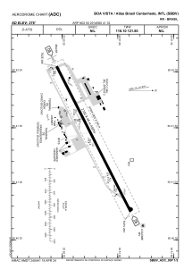
Runways:
| RWY identifier | QFU | Length (ft) | Width (ft) | Surface | LDA (ft) |
| 08 | 63° | 2820 | 280 | ASPH | |
| 26 | 243° | 2820 | 280 | ASPH |
Airport contact information
Address: Boa Vista Brazil