


SBBU - Bauru
Located in Bauru, Brazil
ICAO - SBBU, IATA - BAU
Data provided by AirmateGeneral information
Coordinates: S22°20'42" W49°3'14"
Elevation is 2025 feet MSL.
Magnetic variation is -21.016666667° East View others Airports in São Paulo
Operational data
Special qualification required
Current time UTC:
Current local time:
Weather
METAR: SBBU 292300Z 05004KT CAVOK 31/18 Q1015
TAF: TAF SBBU 291600Z 2918/3006 34005KT 9999 SCT045 TX33/2918Z TN27/3002Z BECMG 2919/2922 CAVOK BECMG 2923/3002 10005KT RMK PGH
Communications frequencies: [VIEW]
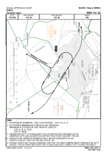
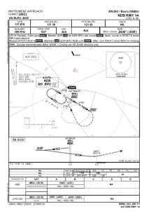
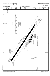
Runways:
| RWY identifier | QFU | Length (ft) | Width (ft) | Surface | LDA (ft) |
| 14 | 0° | 5318 | 492 | ASPH | |
| 32 | 0° | 5318 | 492 | ASPH |
Airport contact information
Address: Bauru Brazil
