


SBBR - Brasília / Presidente Juscelino Kubitschek
Located in Brasília, Brazil
ICAO - SBBR, IATA - BSB
Data provided by AirmateGeneral information
Coordinates: S15°52'16" W47°55'7"
Elevation is 3497 feet MSL.
Magnetic variation is -22.0° East View others Airports in Distrito Federal
Operational data
Special qualification required
Current time UTC:
Current local time:
Weather
METAR: SBBR 280200Z 28002KT CAVOK 22/15 Q1019
TAF: TAF SBBR 280200Z 2806/2906 09005KT CAVOK TN19/2809Z TX29/2817Z BECMG 2812/2815 SCT040 BECMG 2819/2822 CAVOK BECMG 2902/2905 00000KT RMK PGH
Communications frequencies: [VIEW]
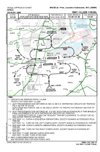
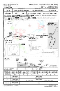
Runways:
| RWY identifier | QFU | Length (ft) | Width (ft) | Surface | LDA (ft) |
| 11L | 86° | 3320 | 280 | ASPH | |
| 29R | 266° | 3320 | 280 | ASPH | |
| 11R | 86° | 3420 | 280 | ASPH | |
| 29L | 266° | 3420 | 280 | ASPH | |
| 11 | 0° | 113 | 113 | ASPH | |
| 29 | 0° | 113 | 113 | ASPH |
Airport contact information
Address: Brasília Brazil
