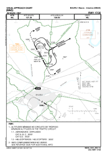
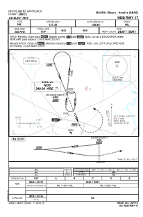


SBAE - Bauru - Arealva
Located in Bauru E Arealva, Brazil
ICAO - SBAE, IATA -
Data provided by AirmateGeneral information
Coordinates: S22°9'28" W49°4'6"
Elevation is 1961 feet MSL.
Magnetic variation is -20.875650578° East View others Airports in São Paulo
Operational data
Special qualification required
Current time UTC:
Current local time:
Weather at : SBBU - Bauru ( 21 km )
TAF: TAF SBBU 292100Z 3000/3012 00000KT CAVOK TN22/3009Z TX24/3011Z BECMG 3000/3003 10005KT RMK PGH
Communications frequencies: [VIEW]
Runways:
| RWY identifier | QFU | Length (ft) | Width (ft) | Surface | LDA (ft) |
| 17 | 0° | 7283 | 984 | ASPH | |
| 35 | 0° | 7283 | 984 | ASPH |
Airport contact information
Address: Bauru E Arealva Brazil