
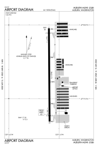


S50 - Auburn Muni
Located in Auburn, United States
ICAO - S50, IATA -
Data provided by AirmateGeneral information
Coordinates: N47°19'39" W122°13'36"
Elevation is 63 feet MSL.
Magnetic variation is 18° East View others Airports in Washington
Operational data
Special qualification required
Current time UTC:
Current local time:
Weather at : KSEA - Seattle-Tacoma Intl ( 15 km )
METAR: KSEA 041653Z 02019KT 10SM FEW020 SCT050 OVC085 11/08 A2952 RMK AO2 SLP001 T01110078
TAF: KSEA 041504Z 0415/0518 02011KT P6SM -SHRA FEW020 SCT035 OVC060 FM042200 24004KT P6SM -SHRA SCT020 OVC035 FM050300 20008KT P6SM SCT015 OVC025 FM050900 20008KT P6SM OVC015
Communications frequencies: [VIEW]
Runways:
| RWY identifier | QFU | Length (ft) | Width (ft) | Surface | LDA (ft) |
| 16 | 180° | 3842 | 75 | ASPH | |
| 34 | 360° | 3842 | 75 | ASPH |
Airport contact information
Address: Auburn United States

