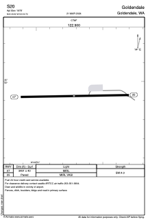


S20 - Goldendale
Located in Goldendale, United States
ICAO - S20, IATA -
Data provided by AirmateGeneral information
Coordinates: N45°49'55" W120°50'43"
Elevation is 1678 feet MSL.
Magnetic variation is 19° East View others Airports in Washington
Operational data
Special qualification required
Current time UTC:
Current local time:
Weather at : KDLS - Columbia Gorge Rgnl/The Dalles Muni ( 34 km )
METAR: KDLS 041553Z AUTO 33006KT 10SM BKN075 OVC090 12/09 A2948 RMK AO2 SLP981 T01220094
TAF: KDLS 041120Z 0412/0512 32006KT P6SM -SHRA OVC050 FM042000 32014G24KT 5SM -RA BR OVC025 FM042300 30013G22KT 6SM -SHRA BR OVC030 FM050600 30013G22KT 4SM -RA BR OVC020
Communications frequencies: [VIEW]
Runways:
| RWY identifier | QFU | Length (ft) | Width (ft) | Surface | LDA (ft) |
| 07 | 89° | 3491 | 40 | ASPH | |
| 25 | 269° | 3491 | 40 | ASPH |
Airport contact information
Address: Goldendale United States