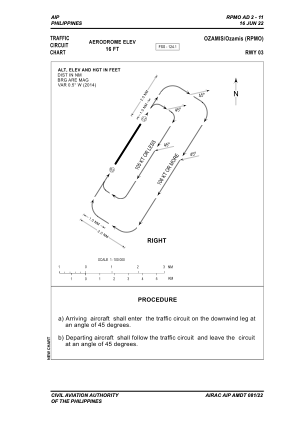


RPMO - Ozamis Community Airport
Located in Ozamis City, Philippines
ICAO - RPMO, IATA - OZC
Data provided by AirmateGeneral information
Coordinates: N8°10'46" E123°50'31"
Elevation is 16 feet MSL.
Magnetic variation is -1° East View others Airports in Misamis Occidental
Operational data
Special qualification required
Current time UTC:
Current local time:
Communications frequencies: [VIEW]
Runways:
| RWY identifier | QFU | Length (ft) | Width (ft) | Surface | LDA (ft) |
| 03 | 33° | 5725 | 148 | CONC | 5725 |
| 21 | 213° | 5725 | 148 | CONC | 5725 |
Airport contact information
Address: Ozamis City Philippines