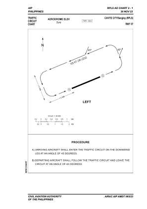


RPLS - Sangley Principal Airport (Class 2)
Located in Sangley Point, Cavite City, Philippines
ICAO - RPLS, IATA - SGL
Data provided by AirmateGeneral information
Coordinates: N14°29'43" E120°54'14"
Elevation is 6 feet MSL.
Magnetic variation is -2° East View others Airports in Cavite
Operational data
Special qualification required
Current time UTC:
Current local time:
Weather at : RPLL - Ninoy Aquino International Airport ( 12 km )
METAR: RPLL 271600Z 12006KT 080V170 9999 FEW025 31/25 Q1010 NOSIG RMK A2983
TAF: TAF RPLL 271100Z 2712/2818 11010KT 9999 FEW025 TX38/2806Z TN30/2721Z TEMPO 2718/2724 SCT025 TEMPO 2803/2809 14017KT
Communications frequencies: [VIEW]
Runways:
| RWY identifier | QFU | Length (ft) | Width (ft) | Surface | LDA (ft) |
| 07 | 68° | 7021 | 148 | ASPH | 7021 |
| 25 | 248° | 7021 | 148 | ASPH | 7021 |
Airport contact information
Address: Sangley Point, Cavite City Philippines