


RJNT - Toyama
Located in Toyama, Japan
ICAO - RJNT, IATA - TOY
Data provided by AirmateGeneral information
Coordinates: N36°38'54" E137°11'15"
Elevation is 77 feet MSL.
View others Airports in Toyama Prefecture
Operational data
Special qualification required
Current time UTC:
Current local time:
Weather
METAR: RJNT 272300Z VRB02KT CAVOK 19/10 Q1015
TAF: TAF RJNT 272305Z 2800/2906 36008KT 9999 FEW020 BECMG 2812/2815 24004KT BECMG 2818/2821 36006KT
Communications frequencies: [VIEW]
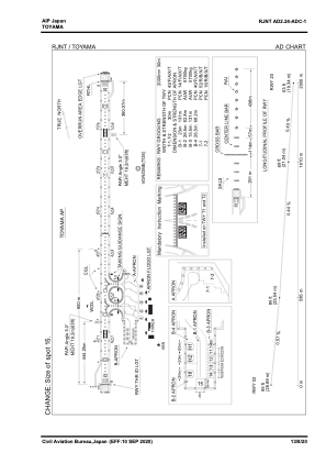
Runways:
| RWY identifier | QFU | Length (ft) | Width (ft) | Surface | LDA (ft) |
| 02 | 14° | 6562 | 148 | ASP | |
| 20 | 194° | 6562 | 148 | ASP |
Airport contact information
Address: Toyama Japan