


PTYA - Yap Intl
Located in Yap Island, Micronesia, Federated States of
ICAO - T11, IATA - YAP
Data provided by AirmateGeneral information
Coordinates: N9°29'56" E138°4'57"
Elevation is 90 feet MSL.
Magnetic variation is +1° East View others Airports in Yap
Operational data
Special qualification required
Current time UTC:
Current local time:
Weather
METAR: PTYA 032155Z 08009KT 12SM FEW016 SCT130 OVC300 29/24 A2980 RMK SLP093 T02870240
TAF: PTYA 031728Z 0318/0418 08007KT P6SM VCSH FEW018 SCT120 FM040000 08012KT P6SM FEW018 SCT120
Communications frequencies: [VIEW]
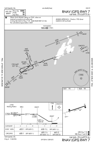
Runways:
| RWY identifier | QFU | Length (ft) | Width (ft) | Surface | LDA (ft) |
| 07 | 72° | 6000 | 150 | ASPH | |
| 25 | 252° | 6000 | 150 | ASPH |
Airport contact information
Address: Yap Island Micronesia, Federated States of