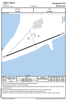


PMDY - Henderson Fld
Located in Midway Atoll,
ICAO - MDY, IATA - MDY
Data provided by AirmateGeneral information
Coordinates: N28°12'5" W177°22'53"
Elevation is 12 feet MSL.
Magnetic variation is 10° East View others Airports in Midway Islands
Operational data
Special qualification required
Current time UTC:
Current local time:
Weather
METAR: PMDY 010403Z AUTO 10SM SCT018 BKN027 OVC110 22/17 A3009 RMK AO2 $
TAF: PMDY 302329Z 0100/0124 06007KT P6SM SCT020 BKN040 FM011200 08008KT P6SM FEW020 BKN045
Communications frequencies: [VIEW]
Runways:
| RWY identifier | QFU | Length (ft) | Width (ft) | Surface | LDA (ft) |
| 06 | 69° | 7800 | 150 | ASPH | 7800 |
| 24 | 249° | 7800 | 150 | ASPH | 7400 |
Airport contact information
Address: Midway Atoll