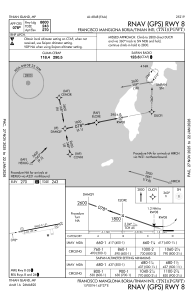


PGWT - Francisco Manglona Borja/Tinian Intl
Located in Tinian Island, Northern Mariana Islands
ICAO - TNI, IATA - TIQ
Data provided by AirmateGeneral information
Coordinates: N14°59'57" E145°37'10"
Elevation is 270 feet MSL.
Magnetic variation is 01° East View others Airports in (unassigned)
Operational data
Special qualification required
Current time UTC:
Current local time:
Weather
METAR: PGWT 022250Z 10008KT 7SM FEW018 SCT045 SCT120 28/25 A2992
TAF: PGWT 022218Z 0222/0318 09013KT P6SM VCSH FEW015 SCT040 TEMPO 0223/0301 VRB13G18KT 5SM -SHRA SCT015 BKN025
Communications frequencies: [VIEW]
Runways:
| RWY identifier | QFU | Length (ft) | Width (ft) | Surface | LDA (ft) |
| 08 | 79° | 8600 | 151 | OTHER | 8600 |
| 26 | 259° | 8600 | 151 | OTHER | 8600 |
Airport contact information
Address: Tinian Island Northern Mariana Islands