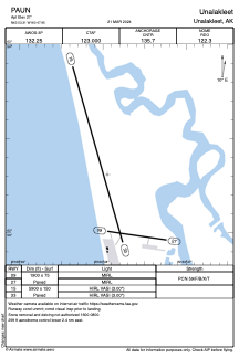


PAUN - Unalakleet
Located in Unalakleet,
ICAO - UNK, IATA - UNK
Data provided by AirmateGeneral information
Coordinates: N63°53'19" W160°47'57"
Elevation is 27 feet MSL.
Magnetic variation is 11° East View others Airports in Alaska
Operational data
Special qualification required
Current time UTC:
Current local time:
Weather
METAR: PAUN 021856Z AUTO 07016KT 10SM BKN070 06/M06 A3000 RMK AO2 SLP164 T00561061
TAF: PAUN 021720Z 0218/0318 07015KT P6SM SKC
Communications frequencies: [VIEW]
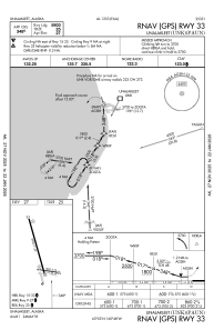
Runways:
| RWY identifier | QFU | Length (ft) | Width (ft) | Surface | LDA (ft) |
| 09 | 98° | 1900 | 75 | ASPH | |
| 27 | 278° | 1900 | 75 | ASPH | |
| 15 | 164° | 5900 | 150 | ASPH | |
| 33 | 344° | 5900 | 150 | ASPH |
Airport contact information
Address: Unalakleet