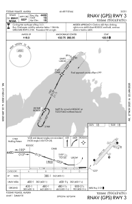


PATG - Togiak
Located in Togiak Village,
ICAO - TOG, IATA - TOG
Data provided by AirmateGeneral information
Coordinates: N59°3'13" W160°23'48"
Elevation is 18 feet MSL.
Magnetic variation is 11° East View others Airports in Alaska
Operational data
Special qualification required
Current time UTC:
Current local time:
Weather
METAR: PATG 030256Z AUTO 05009KT 10SM OVC046 08/04 A2978 RMK AO2 SLPNO T00780039 56004
Communications frequencies: [VIEW]
Runways:
| RWY identifier | QFU | Length (ft) | Width (ft) | Surface | LDA (ft) |
| 03 | 42° | 4400 | 100 | OTHER | |
| 21 | 222° | 4400 | 100 | OTHER | |
| 10 | 112° | 982 | 59 | GRAVEL | |
| 28 | 292° | 982 | 59 | GRAVEL |
Airport contact information
Address: Togiak Village