


PANT - Annette Island
Located in Annette,
ICAO - ANN, IATA - ANN
Data provided by AirmateGeneral information
Coordinates: N55°2'32" W131°34'15"
Elevation is 119 feet MSL.
Magnetic variation is 26° East View others Airports in Alaska
Operational data
Special qualification required
Current time UTC:
Current local time:
Communications frequencies: [VIEW]
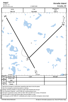
Runways:
| RWY identifier | QFU | Length (ft) | Width (ft) | Surface | LDA (ft) |
| 02 | 0° | 5709 | 150 | GRAVEL | |
| 20 | 0° | 5709 | 150 | GRAVEL | |
| 12 | 0° | 7493 | 150 | ASPH | |
| 30 | 0° | 7493 | 150 | ASPH |
Airport contact information
Address: Annette