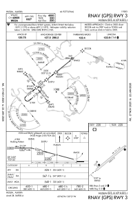


PAHL - Huslia
Located in Huslia,
ICAO - HLA, IATA - HSL
Data provided by AirmateGeneral information
Coordinates: N65°41'52" W156°21'5"
Elevation is 220 feet MSL.
Magnetic variation is 19° East View others Airports in Alaska
Operational data
Special qualification required
Current time UTC:
Current local time:
Weather
METAR: PAHL 021356Z AUTO 06008KT 10SM CLR M03/M11 A3015 RMK AO2 SLP214 T10331106 FZRANO
Communications frequencies: [VIEW]
Runways:
| RWY identifier | QFU | Length (ft) | Width (ft) | Surface | LDA (ft) |
| 03 | 51° | 4000 | 75 | GRAVEL | |
| 21 | 231° | 4000 | 75 | GRAVEL |
Airport contact information
Address: Huslia