
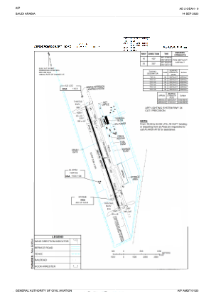


OEAH - Al Ahsa / Al Ahsa (Domestic)
Located in Al Ahsa, Saudi Arabia
ICAO - OEAH, IATA - HOF
Data provided by AirmateGeneral information
Coordinates: N25°17'10" E49°29'10"
Elevation is 588 feet MSL.
View others Airports in Ash Sharqiyah
Operational data
Special qualification required
Current time UTC:
Current local time:
Weather
METAR: OEAH 281900Z 09005KT CAVOK 28/16 Q1011 NOSIG
TAF: TAF OEAH 281000Z 2812/2918 09010KT 9999 FEW040 SCT080 TEMPO 2812/2818 VRB25KT 5000 BLDU TSRA FEW030CB BECMG 2900/2906 03005KT
Communications frequencies: [VIEW]
Runways:
| RWY identifier | QFU | Length (ft) | Width (ft) | Surface | LDA (ft) |
| 16 | 165° | 10039 | 148 | ASP | |
| 34 | 345° | 10039 | 148 | ASP |
Airport contact information
Address: Al Ahsa Saudi Arabia