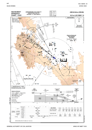
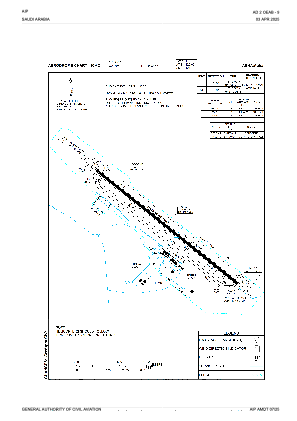


OEAB - Abha
Located in Abha, Saudi Arabia
ICAO - OEAB, IATA - AHB
Data provided by AirmateGeneral information
Coordinates: N18°14'25" E42°39'23"
Elevation is 6858 feet MSL.
View others Airports in Asir
Operational data
Special qualification required
Current time UTC:
Current local time:
Weather
METAR: OEAB 291500Z 20012KT 9999 SCT020 21/12 Q1022 NOSIG
TAF: TAF OEAB 291100Z 2912/3018 21015KT 9999 FEW020 TEMPO 2912/2920 VRB25KT 6000 TSRA SCT020 FEW025CB BECMG 2918/2920 19006KT BECMG 3006/3008 21015KT
Communications frequencies: [VIEW]
Runways:
| RWY identifier | QFU | Length (ft) | Width (ft) | Surface | LDA (ft) |
| 13 | 126° | 10991 | 148 | ASP | |
| 31 | 306° | 10991 | 148 | ASP |
Airport contact information
Address: Abha Saudi Arabia