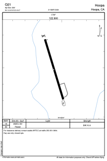


O21 - Hoopa
Located in Hoopa, United States
ICAO - O21, IATA -
Data provided by AirmateGeneral information
Coordinates: N41°2'29" W123°40'4"
Elevation is 356 feet MSL.
Magnetic variation is 17° East View others Airports in California
Operational data
Special qualification required
Current time UTC:
Current local time:
Weather at : KACV - California Redwood Coast-Humboldt County ( 38 km )
TAF: KACV 040023Z 0400/0424 18010KT 2SM RA BR SCT007 OVC015 FM040400 18012KT 1SM +RA BR OVC003 FM040900 31009G19KT 2SM RA BR SCT003 OVC007 FM041200 02007KT 4SM -RA BKN015 OVC030 FM041700 26008KT 5SM -TSRA BKN020CB OVC040
Communications frequencies: [VIEW]
Runways:
| RWY identifier | QFU | Length (ft) | Width (ft) | Surface | LDA (ft) |
| 14 | 0° | 2325 | 50 | ASPH | |
| 32 | 0° | 2325 | 50 | ASPH |
Airport contact information
Address: Hoopa United States