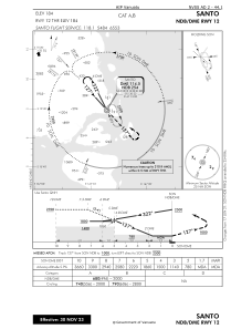


NVSS - Santo
Located in Luganville, Vanuatu
ICAO - NVSS, IATA - SON
Data provided by AirmateGeneral information
Coordinates: S15°30'21" E167°13'17"
Elevation is 184 feet MSL.
View others Airports in Sanma
Operational data
Special qualification required
Current time UTC:
Current local time:
Weather
METAR: NVSS 280500Z 14007KT 9999 TS FEW018CB SCT020 BKN040 27/25 Q1009
TAF: TAF NVSS 280500Z 2806/2906 14006KT 9999 SCT020 BKN040 BKN100 INTER 2806/2812 9000 SHRA FEW010 BKN018 OVC038 INTER 2806/2812 7000 TSRA FEW008 BKN018 FEW020CB OVC090
Communications frequencies: [VIEW]
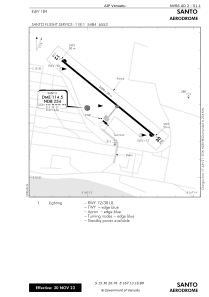
Runways:
| RWY identifier | QFU | Length (ft) | Width (ft) | Surface | LDA (ft) |
| 12 | 129° | 6562 | 98 | ASP | |
| 30 | 309° | 6562 | 98 | ASP |
Airport contact information
Address: Luganville Vanuatu