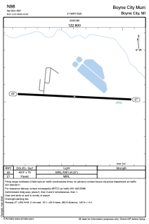


N98 - Boyne City Muni
Located in Boyne City, United States
ICAO - N98, IATA -
Data provided by AirmateGeneral information
Coordinates: N45°12'32" W84°59'24"
Elevation is 660 feet MSL.
Magnetic variation is -05° East View others Airports in Michigan
Operational data
Special qualification required
Current time UTC:
Current local time:
Weather at : KCVX - Charlevoix Muni ( 25 km )
METAR: KCVX 050355Z AUTO 22005KT 7SM RA BKN029 BKN039 OVC095 13/11 A2985 RMK AO2 T01250113 402390062
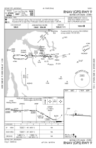
Communications frequencies: [VIEW]
Runways:
| RWY identifier | QFU | Length (ft) | Width (ft) | Surface | LDA (ft) |
| 09 | 93° | 4001 | 75 | ASPH | |
| 27 | 273° | 4001 | 75 | ASPH |
Airport contact information
Address: Boyne City United States