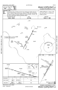


N51 - Solberg/Hunterdon
Located in Readington, United States
ICAO - N51, IATA -
Data provided by AirmateGeneral information
Coordinates: N40°34'58" W74°44'12"
Elevation is 189 feet MSL.
Magnetic variation is -10° East View others Airports in New Jersey
Operational data
Special qualification required
Current time UTC:
Current local time:
Weather at : KSMQ - Somerset ( 7 km )
METAR: KSMQ 031453Z AUTO 14007KT 10SM FEW022 OVC027 16/11 A3017 RMK AO2 SLP214 T01560106 51013
Communications frequencies: [VIEW]
Runways:
| RWY identifier | QFU | Length (ft) | Width (ft) | Surface | LDA (ft) |
| 04 | 29° | 5598 | 50 | OTHER | |
| 22 | 209° | 5598 | 50 | OTHER | |
| 10 | 81° | 2010 | 100 | GRASS | |
| 28 | 261° | 2010 | 100 | GRASS | |
| 13 | 119° | 3444 | 200 | GRASS | |
| 31 | 299° | 3444 | 200 | GRASS |
Airport contact information
Address: Readington United States
