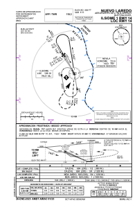


MMNL - Nuevo Laredo Quetzalcoatl
Located in Nuevo Laredo, Mexico
ICAO - MMNL, IATA - NLD
Data provided by AirmateGeneral information
Coordinates: N27°26'36" W99°34'12"
Elevation is 484 feet MSL.
View others Airports in Tamaulipas
Operational data
Special qualification required
Current time UTC:
Current local time:
Weather
TAF: TAF COR MMNL 281850Z 2818/2918 01015KT P6SM SKC TEMPO 2820/2824 36015G25KT FM290100 03005KT P6SM SCT020 FM291000 12005KT 3SM BR BKN015 BECMG 2915/2916 5SM HZ SCT020
Communications frequencies: [VIEW]
Runways:
| RWY identifier | QFU | Length (ft) | Width (ft) | Surface | LDA (ft) |
| 14 | 151° | 6562 | 148 | ASP | |
| 32 | 331° | 6562 | 148 | ASP |
Airport contact information
Address: Nuevo Laredo Mexico