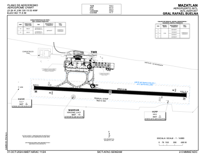


MMMZ - Mazatlan Aeropuerto Internacional Gral. Rafael Buelna
Located in Mazatlan, Mexico
ICAO - MMMZ, IATA - MZT
Data provided by AirmateGeneral information
Coordinates: N23°9'41" W106°15'52"
Elevation is 38 feet MSL.
View others Airports in Sinaloa
Operational data
Special qualification required
Current time UTC:
Current local time:
Weather
METAR: MMMZ 290742Z 00000KT 10SM SKC 14/12 A2986 RMK ISOL CI
TAF: TAF MMMZ 290513Z 2906/3006 34005KT P6SM SCT250 TX29/2919Z TN12/2912Z FM291800 28010KT P6SM BKN250 FM300500 34005KT P6SM SCT250
Communications frequencies: [VIEW]
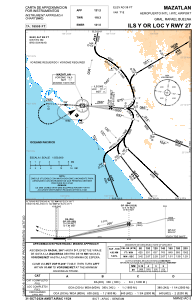
Runways:
| RWY identifier | QFU | Length (ft) | Width (ft) | Surface | LDA (ft) |
| 09 | 93° | 8868 | 197 | UNK | |
| 27 | 273° | 8868 | 197 | UNK |
Airport contact information
Address: Mazatlan Mexico
Other aviation service providers
Flight schools

Centro de Estudios Aeronáuticos de Mazatlán
Centro de Estudios Aeronáuticos de Mazatlán
ceammzt@hotmail.com669 205 5503
Colegio del Aire de Sinaloa
Colegio del Aire de Sinaloa
colegiodelairedesinaloa@gmail.com+52 667 760 0968